
Agriculture
Planting & Reforestation with Drones Transparent, measurable plantation work.
Plantation projects succeed only when planning and monitoring are done properly. Many reforestation and green-belt programs fail due to poor site preparation, water stress, or lack of follow-up tracking.
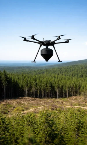
Overview
Planting and reforestation drones solve this by providing baseline site surveys, boundary mapping, progress monitoring, and geo-tagged documentation—making plantation work transparent, measurable, and easier to manage. Ideal for CSR plantations, industrial green belts, watershed projects, campuses, highways/rail corridors (site-permit dependent), and large community plantations.
What Drones Help with in Planting & Reforestation
| Stage | What Drones Help With | Output / Benefit |
|---|---|---|
| 1) Site Survey & Planning (Before Planting) | Boundary mapping & plot demarcation; Slope and drainage understanding (flow/collection zones); Identification of access points, water points & risk zones; Baseline aerial photo documentation | Clear layout plan with baseline proof for approvals, planning & execution |
| 2) Plantation Progress Monitoring (After Planting) | Coverage check (planted vs unplanted zones); Growth variation tracking (healthy vs weak patches); Damage assessment (drought, storms, grazing, fire risk); Geo-tagged proof for CSR & stakeholders | Progress maps with geo-tagged photos to track completion and detect issues early |
| 3) Survival Tracking & Reporting | Periodic aerial documentation for survival estimation; Identification of replanting / extra watering zones; Seasonal before-and-after comparison reports | Survival-focused action zones with measurable improvement tracking for reporting & closure |
Swipe sideways to see the full table.
Benefits (Project + Business Perspective)
01
Audit-Ready Documentation:
Geo-tagged images and reports support compliance and stakeholder reviews.
02
Faster Monitoring Across Large Land
Cover wide areas quickly without manual walking rounds.
03
Early Detection of Failures
Identify dry zones, stress, erosion impact, or damage early for timely action.
04
Improved Team Coordination
Clear maps help teams focus on weak zones first.
05
Better Transparency for CSR and Large Projects
Visual proof of work completion and progress tracking.
Not sure which agricultural drone fits your crop and field size? We’ll recommend the right setup.
How It Works
- Baseline survey – boundary, access, slope/drainage, existing vegetation condition
- Plantation mapping – mark blocks and monitoring checkpoints
- Scheduled monitoring flights – monthly/quarterly as per project plan
- Issue zone marking – weak growth zones, dry areas, damage spots
- Report delivery – progress maps + photos + action zones for field teams
What You Receive (Deliverables)
01
Baseline Map
Baseline map: Plot boundary with key points (access, water points, risk zones).
02
Progress Reports
Periodic updates with geo-tagged images for proof and tracking.
03
Growth Variation Zones
Classified as Healthy / Weak / Critical for quick prioritization.
04
Action List
Clear guidance on watering support, replanting zones, and protection needs.
05
Before/after Documentation:
CSR-ready evidence for reporting, audits, and project closure.
Planting & Reforestation with Drones
Best Use Cases
01
CSR Plantation Programs
Annual proof, progress reporting, and stakeholder documentation.
02
Industrial Green Belt Plantations
Compliance tracking and repeatable progress evidence.
03
Campus Plantations
Schools, hospitals, and institutions needing clean reporting and easy monitoring.
04
Watershed/community Restoration Projects
Large-area monitoring with clear zone marking.
05
Post-Monsoon Reviews
Identify damage, weak zones, and replanting needs quickly.
Planting & Reforestation with Drones
Services We Offer
01
Baseline Survey + Planting Support Mapping
Boundary mapping + layout planning + water point identification + baseline documentation for approvals and execution.
02
Quarterly Monitoring Program (Most Common)
Progress documentation with survival pattern assessment and clear action zones for field teams.
03
Full Season Monitoring (Monthly / Custom)
Ideal for high-investment projects that need tighter control and faster corrective actions during early growth.
04
Combined Service Soil & Water + Reforestation Monitoring
Improves survival rate by linking drainage and water-stress insights with plantation planning and follow-up monitoring.
Planting & Reforestation with Drones
Why Choose Us
01
Stakeholder-Friendly Reports
CSR-ready documentation that’s easy to present and review.
02
Repeatable Monitoring
Consistent surveys so progress is measurable across seasons.
03
Clear Action Zones
Priority marking to improve survival rate through timely watering/replanting/protection.
04
Flexible for Any Scale
Works for single sites as well as multi-location plantation programs.
Agriculture
Related Solutions
Agriculture
Agricultural Spraying Drones
Planned-route spraying of pesticides, fungicides and foliar nutrients with uniform coverage and less labour.
Explore
Agriculture
Drone for Crop Monitoring
Maps and photo proof of crop health, stress zones and problem patches so you can act early.
Explore
Agriculture
Agri Field Mapping & Survey Drones
Faster land review, boundary checks and field planning for farms, orchards and plantations.
Explore
Agriculture
Drone for Irrigation Systems
Spot dry patches, leaks, blocked sprinklers and waterlogged areas before they hit yield.
Explore
Agriculture
Soil & Water Management with Drones
Reveal waterlogging, drainage paths, erosion and bund damage to plan lasting fixes.
Explore
Agriculture
Livestock Monitoring Drones
Review paddocks, herd movement, water points and boundaries without long manual patrols.
Explore
Planting & Reforestation Drones
Frequently Asked Questions
Can’t find your answer? Call us on +91 94870 87778 or send an enquiry.
Can drones be used for plantation and reforestation monitoring?
Yes. Drones are widely used to document plantation progress, map coverage, and track weak zones over time.
Can a drone measure survival rate of planted saplings?
Drones help estimate survival patterns and highlight replanting zones. Exact survival counts may need sample ground verification.
How often should plantation monitoring be done?
Quarterly is common for CSR programs. Monthly monitoring is better in early growth stages and during dry seasons.
What can a drone report show for CSR and audits?
Baseline maps, geo-tagged photos, progress coverage, growth variation zones (Healthy/Weak/Critical), and before/after documentation.
Can drones identify dry zones and watering needs?
Yes. Drone surveys can highlight stress zones and drainage/slope patterns that indicate where watering support is needed.
Can drones detect plantation damage after storms or grazing?
Yes. They can quickly show damaged blocks, trampled areas, missing patches, and boundary breach zones for faster action.
Does drone monitoring replace field visits completely?
No. Drones reduce manual walking and help prioritize where to inspect first, but ground checks are still useful for confirmation and corrective work.
Are drones useful for industrial green belts and compliance reporting?
Yes. Drone documentation supports compliance, repeat monitoring, and clear evidence of green belt progress.
Can drones help plan plantation layout before planting starts?
Yes. Boundary mapping and slope/drainage insights help plan blocks, access paths, watering points, and protection zones.
What deliverables will we get after each monitoring visit?
A progress report with maps + geo-tagged photos, action zones, and a simple checklist (watering/replanting/protection).
Let’s talk
Ready to Bring Drones to Your Farm?
Tell us your crop, field size and location. We’ll suggest the right drone and service model.