
Agriculture
Soil & Water Management with Drones Fix drainage and erosion at the root.
Good farming depends on two basics: healthy soil and controlled water movement. When drainage is poor, crops suffer.
Overview
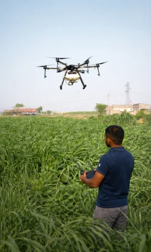
When runoff cuts channels or soil erodes, productivity drops year after year. Soil and water management with drones helps you see the field like a planner—highlighting waterlogging zones, drainage paths, erosion risk areas, bund damage, and slope patterns so you can fix the root cause. Ideal for large farms, estates, FPOs, plantation operators, and land development teams
Soil & Water Management with Drones
What a Drone Helps You Understand
A drone survey gives a full-field view to identify:
- Where water collects and stays (waterlogging)
- Where water runs fast and cuts soil (erosion channels)
- How slope/terrain affects runoff and irrigation efficiency
- Areas with repeat patchy growth caused by soil variation/compaction
- Bund lines, borders, and storm damage weak points
- Drainage blocks near roads, culverts, bund corners, outlets
Key Problems Drones Help Identify (Quick View)
| Issue Identified | Impact on Field | Recommended Action Plan |
|---|---|---|
| Waterlogging Areas | Root stress, crop yellowing, reduced yield potential | Improve drainage system, land leveling, create outlet channels |
| Natural Drainage Flow Paths | Uneven moisture distribution and uncontrolled runoff | Install structured drain lines, design safe discharge outlets, reshape bunds |
| Soil Erosion / Topsoil Loss | Formation of rills and gullies, nutrient depletion | Implement erosion control measures, manage slope gradients |
| Bund Damage / Boundary Breaks | Floodwater intrusion and soil wash-off | Repair and reinforce bunds, strengthen weak boundary zones |
| Soil Variability Affecting Growth | Recurring underperformance patches | Conduct zone-wise soil improvement and corrective treatment planning |
Swipe sideways to see the full table.
Not sure which agricultural drone fits your crop and field size? We’ll recommend the right setup.
Benefits (Farmer + Business Perspective)
01
Better Decisions, Less Guesswork
See actual field patterns clearly and plan improvements with confidence.
02
Reduce Water Waste
Fix drainage/leveling so water stays where crops need it instead of running off.
03
Improve Yield Uniformity
Correct waterlogging and runoff stress zones for more consistent crop growth.
04
Lower Long-Term Maintenance Cost
Stop erosion early before repairs become bigger and expensive.
05
Useful Documentation
Maps and photos support planning, reporting, and tracking work execution.
How It Works
- Site Input – crop plan, irrigation type, known issues, season timing
- Drone Survey Flight – systematic block-wise coverage
- Problem Zone Marking – waterlogging, runoff paths, erosion risk, bund weak points
- Action Plan – simple steps for drainage, bund strengthening, flow control
- Report Delivery – maps + photos + priority zones (High / Medium / Observe)
What You Receive (Deliverables)
01
Field Overview Map
Marked problem zones for quick understanding and planning.
02
Photo Evidence
Erosion channels, bund damage points, and pooling/waterlogging zones.
03
Portfolio / Multi-Site Maintenance
One SOP across all sites with centralized reporting and cleaning history—optional thermal/visual logs to support O&M planning.
04
Improvement Suggestions
Practical guidance like drain line locations, outlet points, and repair zones.
05
Optional Before/after Survey
Repeat mapping after improvements for proof and progress tracking.
Soil & Water Management with Drones
Best Use Cases
01
One-Time Soil & Water Survey
Best for farms facing repeated waterlogging, erosion, or poor drainage—quick mapping + priority action zones.
02
Seasonal Improvement Program (Estate / FPO)
Pre-monsoon + post-monsoon surveys with action tracking to measure improvements over the season.
03
Farm Development Support (New Land / Expansion)
Drone survey with planning maps for drainage layout, bund positioning, access paths, and boundary strengthening.
04
Combined Plan Irrigation Audit + Soil/Water Survey
Ideal for improving both water supply performance and water movement/drainage control across the farm.
Soil & Water Management with Drones
Services We Offer
01
Pre-Season Field Improvement Planning
Identify weak zones and fix drainage/bunds before sowing.
02
Post-Monsoon Damage Assessment
Map bund breaks, erosion channels, and waterlogging pockets for quick repair planning.
03
Drainage Planning for Low-Lying Fields
Spot runoff paths and pooling areas in heavy soils with poor drainage.
04
Estate-Level Improvement Programs
Standardized mapping across multiple blocks/plots for tracking and execution.
05
Before Plantation/orchard Development
Better layout planning for drains, bunds, access paths, and long-term water control.
Soil & Water Management with Drones
Why Choose Us
01
Farmer-Friendly Outputs
Clear action zones and priorities—no complicated technical reports.
02
Repeatable Surveys
Track improvements over time with consistent mapping and comparisons.
03
Flexible for Any Scale
Works for single farms, estates, and multi-plot FPO programs.
04
Practical Recommendations
Focused on steps you can implement on-ground (drains, bund repairs, outlets, flow control).
Agriculture
Related Solutions
Agriculture
Agricultural Spraying Drones
Planned-route spraying of pesticides, fungicides and foliar nutrients with uniform coverage and less labour.
Explore
Agriculture
Drone for Crop Monitoring
Maps and photo proof of crop health, stress zones and problem patches so you can act early.
Explore
Agriculture
Agri Field Mapping & Survey Drones
Faster land review, boundary checks and field planning for farms, orchards and plantations.
Explore
Agriculture
Drone for Irrigation Systems
Spot dry patches, leaks, blocked sprinklers and waterlogged areas before they hit yield.
Explore
Agriculture
Planting & Reforestation with Drones
Baseline surveys, boundary mapping and geo-tagged progress tracking for plantation projects.
Explore
Agriculture
Livestock Monitoring Drones
Review paddocks, herd movement, water points and boundaries without long manual patrols.
Explore
Soil & Water Management with Drones
Frequently Asked Questions
Can’t find your answer? Call us on +91 94870 87778 or send an enquiry.
Can a drone detect waterlogging areas in a farm?
Yes. Drone surveys clearly show low-lying pooling zones—especially after irrigation or rainfall—so you can plan drains or leveling.
Can drones help plan drainage lines and outlets?
Yes. Drone mapping shows natural runoff paths and blockage points, helping you decide where drain lines and outlet points should go.
Will a drone survey show field slope and runoff direction?
It can indicate slope/runoff patterns from visual mapping, and with advanced mapping it can support better field planning for water movement.
Can drones identify erosion risk areas before major damage happens?
Yes. Early rills, runoff cutting lines, and weak bund edges can be spotted so you can prevent bigger soil loss.
Does drone survey replace soil testing?
No. Drones show where the problem is (pattern/zones). Soil tests confirm what the soil issue is (pH, nutrients, salinity, texture).
When is the best time to do a soil & water drone survey?
Best after rainfall/irrigation (to see water movement) and post-monsoon (to assess erosion/bund damage). Pre-season surveys help plan improvements.
Is this useful for heavy clay soils and low-lying lands?
Yes. These fields commonly face waterlogging and slow drainage—drone mapping helps identify pooling pockets and fix priorities.
Can drone surveys help in bund repair planning?
Yes. It helps locate bund weak points, boundary breaks, and overflow spots so repairs can be planned zone-wise.
What deliverables will I receive after the survey?
A field overview map, marked problem zones (High/Medium/Observe), photos of key issues, and a simple action plan.
Can you do a before/after survey to prove improvement?
Yes. Repeat surveys can compare maps after drain/bund work to confirm improvement and document results.
Is it useful for estates and FPO multi-plot programs?
Very useful—standard reporting across blocks/plots makes execution tracking and budgeting easier.
Can this help before starting a new plantation or orchard?
Yes. It supports layout planning for drains, bunds, access paths, and long-term water control before planting starts.
Let’s talk
Ready to Bring Drones to Your Farm?
Tell us your crop, field size and location. We’ll suggest the right drone and service model.